BC Physical Geography 12Whadya' do in Geog 12? Why take the course? We examine how the earth works -- in the air, on the ground, under the ground, and among living things. We examine how humans adapt to and change or alter the physical environments around them. We ask questions about what's going on here and what it all means... what's our connection to the world around us? This is a course that helps students become more place-conscious and aware of how their surrounding were shaped and shape us in return.
Course Outline and Expectationsnew Course Introduction and Outline for September 2016
|
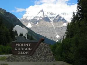
Mount Robson, British Columbia http://commons.wikimedia.org/wiki/File:Mount_Robson_Park-British_Columbia-Canada.JPG
|
Unit 1 The Study of Geography1A What is Geography? - Themes and Perspectives
1B Geographic Thinking 1C Maps and Map Skills, Round 1 1D The Earth our Home and Planet 1E Regions and Peoples 1F Pressures on our Planet Projects, Tests, Field Trips, etc. Unit 2 Earth's Structures and Spheres2A Geology
2B Plate Tectonics, Faults and Folds 2C Earthquakes and Volcanoes 2D Atmospheric Circulation 2E Weather and Climate 2F Ecosystems, Biomes, and Soil Projects, Tests, Field Trips, etc. Unit 3 Forces that Shape the Land3A Weathering Processes
3B Mass Wastage and Natural Disasters 3C River Landscapes 3D Glacial Landscapes 3E Deserts, Caves, and Groundwater 3F Coastal Landforms Projects, Tests, Field Trips, etc. Unit 4 Human-Environment Dynamic4A Cultural Adaption to Space and Resources
4B Early Economic Systems and Patterns 4C Global Agriculture 4D Global Industry 4E Urbanization and Life of a City 4F Forestry in BC Projects, Tests, Field Trips, etc. Themes of Geography Photo EssayLocation (Absolute and Relative)
Nature of Place (Physical and Human Characteristics)
Human-Environment Interactions
Regions (Formal, Informal or Vernacular, Functional)
Movement (people, goods, things, ideas)
|
Course ExpectationsYour teacher does not have many rules... mostly it is expected that students will operate with a few principles in mind:
Big Ideas for Geography 12
Webriver BlogThis blog -- http://webriver.blogspot.ca -- is for online assignments and discussion in Social Studies and Geography. We will use this sometimes for our class.
How does Geog 12 connect with life after high school?
University programs in geography, arts, and sciences. Careers in urban planning, civil engineering, digital mapping, environmental consulting, forestry, geology & soil science, education, coding (e.g. location-based data), archaeology, and travel & tourism industry.
Course "Competencies"
|
Geography 12 Links
BC Provincial Exams Website
Information on Geography 12 exam and others. Good place for students to figure out what the provincial exam will look like.
Atlapedia: Canada
A concise description of Canada (including its geography) in Atlapedia Online.
Ask an Expert: Canadian Geography
CLN's "Ask an Expert" page has about 100 links to specialists in the field who can serve as a valuable source of curricular expertise for both students and teachers.
BC Ministry of Environment, Lands and ParksInformation on the air, land and water of BC is provided. Topics include: air quality, car emissions & preventing pollution, climate change, smoke control, parks, crown land, wildlife, managing waste, water & land & habitat stewardship, managing pesticides, watershed management, water licenses and fisheries.
Canada Centre for Inland Waters
The focus of CCIW is on water research, generating new knowledge that is critical for the effective management of Canada's freshwater and marine resources. Their servers host information from: National Water Research Institute (our freshwater ecosystems), Great Lakes Information Management Resource (source of information and references about the Great Lakes), Bayfield Institute (fisheries research, fisheries and habitat management), and more.
Canadian Communities Atlas Project
This web page provides information to prospective participants in an Internet project whereby Canadian students (Grades 4-12) build an online Atlas Site of their community (physical, economic, human, cultural and historic geography). Project organizers provide thematic topics for student to research their community and this research is then entered into HTML templates to become part of the online Atlas. Students can participate as a class, a school, or even as a district.
Canadian Geographic Online
Current and back issues of this Canadian journal.Careers in Geography
Although not a Canadian document, this pamphlet from Texas and the National Geographic Society will apply to Canadian students. It has information on "Why Study Geography?", "Geography and Careers" and "The Variety of Geographic Fields."
City.Net: Canada
Links to information about Canada, for example cities, provinces, or regions.
Gary's Geographical Gnome
A massive meta-list of links to topics related to geography or earth science aimed for high school students and teachers. Links are briefly annotated and organized under headings such as: Physical Environment, Human Environment, Environmental Concerns and Resource Page, and Mapping and Satellite Imaging.
Geography 12 Home Page
Teachers from SD#43 (Coquitlam) created this meta-list of links to resources which support the BC Geography 12 course. Links are organized in a variety of ways, for example you can access resources that have direct ties to specific areas of the course outline.
GeoWorld: WWW Education Geography Sites
A massive metalist with a Canadian focus.
How Far Is It?
"This service uses the University of Michigan Geographic Name Server and a supplementary database of world cities to find the latitude and longitude of two places, and then calculates the distance between them (as the crow flies). It also provides a map showing the two places, using the Xerox PARC Map Server."
National Atlas on SchoolNet
This Canadian Atlas has a wide variety of geographical resources. Browse through the site from the main menu (above) or link directly to some of their resources with particular K-12 appeal (below).
Ask the Harkster
Ask an Expert in Canadian Geography.
Canadian Issues
Web pages developed around various Canadian issues, some of which are geographical in nature.
Defacto: Geographical Facts about Canada
A Canadian factbook.
Geographical Names
A searchable database on Canadian names.
Interactive Geography Quiz
Test your knowledge of Canadian Geography.
Make a Map
Create customized maps from Canadian geographic information.
Maps of All Kinds
Select from a variety of Canadian maps.
Natural Resources, Canada
This is the federal government's web site for The Department of Natural Resources. NRCan has a mandate to promote the sustainable development and responsible use of Canada's mineral, energy, metal, and forestry resources. Click above to go to NRCan's home page for general information on NRCan (e.g., access to their libraries, stats on natural resources). Click below to go directly to some of their sector web pages.
Canadian Forest Service
Geological Survey of Canada
Statistics Canada: Canadian Statistics A wealth of raw data on Canada. Check out in particular the pages on the "Canadian Dimensions: The Land"
Tables and Graphs based on Canadian Statistics
Tables and charts of Canadian geographical data taken from Stats Canada. At the bottom of the page, you can click a button to go "Back to Teaching and Learning about Canada". This is a meta-list of links to resources on Canada that might be useful for Social Studies classes. Geography is one element under which links are organized.